What's In the Air We Breathe
The Environmental Protection Agency (EPA) and California Air Resources Board (CARB) set Ambient Air Quality Standards (AAQS) for six common air pollutants, known as criteria pollutants. At the APCD, we monitor ambient concentrations of these pollutants across the county.
Ground-level Ozone
(opens in a new tab)is created when nitrogen oxides (NOx) react
with volatile organic compounds (VOCs) in the presence of sunlight
Particulate Matter
is comprised of windblown dust and combustion particles
Nitrogen Dioxide
(opens in a new tab)is a principal component of smog,
primarily emitted by the burning of fossil fuels
Carbon Monoxide
is created by the combustion of any fuel. It is of primary concern indoors,
where fuel-burning appliances and poor ventilation can lead to oxygen deprivation
Sulfur Dioxide
(opens in a new tab)is the most common species of gases called sulfur oxides (SOx)
SOx emissions result from the burning of sulfur-containing materials, like fossil fuels
Lead Pollution
(opens in a new tab)in the air has decreased by 99% nationally since 1980
Remaining sources include ore and metals processing, and piston-engine aircraft
Each year, our data is compiled into an Annual Air Quality Report for comparison against the State and National AAQS. These reports provide information on the measured air quality concentrations and trends in Santa Barbara County, as well as a summary of the AAQS and exceedances for the year.
We also prepare an annual air monitoring network plan, which includes a statement of purpose for each monitor and demonstrates compliance with federal regulations, and a 5-year network assessment of the air quality surveillance system in Santa Barbara County.
Our most current Network Assessment, Network Plan, and Annual Air Quality Report are available in the Additional Resources section below.
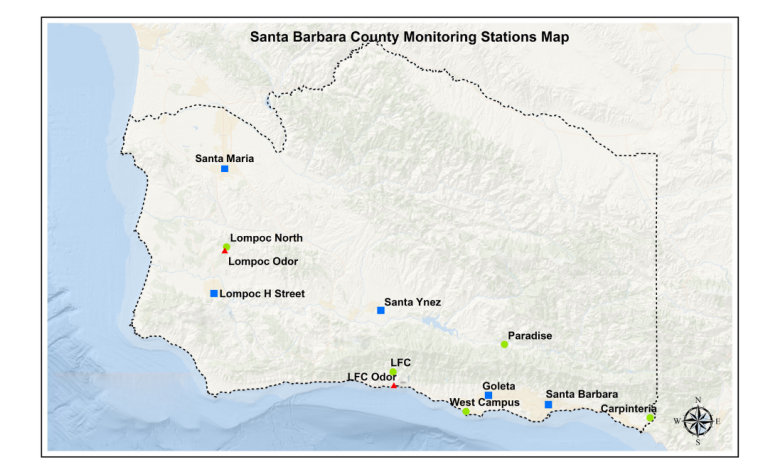
Ambient Air Monitoring Network
Each monitoring station is sited to meet one or more of the objectives below. The network of all stations combined must meet all four objectives.
- Determine representative concentrations of air pollution in highly populated areas;
- Determine the impact of specific businesses or other sources of pollution;
- Determine general background pollution levels in areas not directly affected by cars, businesses and other man-made pollution sources; and
- Determine the highest pollution levels in the county.
Types of Stations
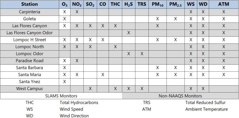
Stations fall into two primary categories: SLAMS (State and Local Air Monitoring Stations) and Industrial stations. The station category and location largely determine which pollutants are measured at each station.
SLAMS measure urban and regional air quality. All five SLAMS are operated by the APCD (Lompoc, Santa Ynez, Santa Barbara, Santa Maria, and Goleta).
Seven Industrial stations are used to determine baseline air quality and the impacts of specific operations, such as oil and gas facilities. These stations are located in the immediate vicinity to measure specific pollutants emitted by the facility, or they are located downwind to measure the ozone formation from the emitted pollutants. The ozone monitors at three of the Industrial stations are classified as SLAMS due to their tendency to record the highest ozone levels in county. While most Industrial stations are operated by the facility, Las Flores Canyon is currently operated by the APCD.